A Visit to a Cairn
A day awash with rain gives us a chance to start inputting the data we've recorded so far into a database and the volunteers a chance to rest their legs before we head back out for a hopefully dryer day of surveying tomorrow. The weather in the first half of this week has been treating us well, although it has been noticeably colder and windier at times than last week. Our survey continues to make good progress, culminating last thing on Wednesday with us reaching the Bronze Age cairn that had previously been recorded, but was exciting to find nonetheless.
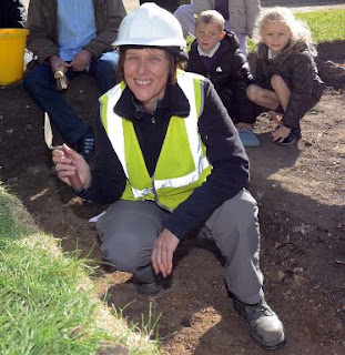
Sometimes during these surveys we do come across features that have already been discovered and recorded, and it's always worth recording and photographing them again. This allows us to keep track of the condition of these monuments, and should there be any damage we can take action to prevent further demise of archaeological monuments. It also allows us to confirm the location of monuments as technology improves and hand-held GPS devices become more accurate, as occasionally sites won't have been recorded or revisited for long periods of time.

As you can see, the cairn that we visited is in good condition, and as it is on a public right of way the recorded location of it was pretty accurate. As we stood next to the cairn looking over South Lakeland towards Morecambe Bay we couldn't help but imagine a vast prehistoric landscape and it makes us wonder what other archaeological treasures we might find during the remainder of our survey.
If you'd like to join us there are still places available, book online at: https://www.eventbrite.co.uk/e/rusland-horizons-bethecar-moor-archaeological-survey-registration-48867752764. You can also keep up to date with live updates from the field on our social media at:
https://www.instagram.com/naa_ltd/?hl=en and https://www.facebook.com/NAAltd/

Comments
Post a Comment